The Tongariro Alpine Crossing is among the most scenic and inspiring hikes in New Zealand. It's important to consider taking a guided hike especially during the winter season.
The Department of Conservation encourage visitors to the Tongariro Alpine Crossing to book in advance. There is no cost to book. For more information, visit the Tongariro Alpine Crossing Booking Site.
** Please remember this is a hike in an alpine environment in which we recommend you use a guide.The weather is changeable, ice and snow are present throughout the year **
The Tongariro Alpine Crossing is the best one-day hike in New Zealand and is regarded as one of the top ten single-day treks in the world. Loved by locals and visitors alike, the Tongariro Alpine Crossing is nestled in the magnificent UNESCO Dual World Heritage site of Tongariro National Park - globally recognised for both its cultural and natural significance and as New Zealand’s oldest national park.With its unique terrain, spectacular views, otherworldly landscapes, volcanic peaks, and turquoise lakes, the Tongariro Alpine Crossing attracts hikers from around the world throughout the year as an unforgettable, one-of-a-kind destination experience.
A sacred place
A genuine wonder of the natural world and the crown jewel of Ruapehu, the Tongariro Alpine Crossing is a challenging journey across a remarkable volcanic landscape with incredible diversity and unique flora and fauna. From ancient lava flow, stunning emerald lakes, and alpine peaks this pristine environment is sacred to local iwi (Māori tribe) and it is advised that all waterways should not be entered or touched.
Nearby villages and towns for the Tongariro Alpine Crossing
Each year between October and the 30th of April, there is a four-hour time restriction for private vehicles at the Mangatepopo Road-end. This gives visitors time to enjoy short walks like the Soda Spring track, but people wanting to do the entire hike, which takes an average of 7-8 hours, will need to book one of the many Tongariro Alpine Crossing shuttle transport options. There is a fantastic range of local shuttle operators to choose from.
There are several local shuttle transport operators to assist you with getting to and from the track start and finish, with some who also offer pick up from nearby accommodation as well as one-way and return shuttles for a variety of local hikes including the NZ Great Walk Tongariro Northern Circuit, the Round the Mountain Track, and other shorter local hikes. You may also connect with one of Manaaki Rangers at the start of the Tongariro Alpine Crossing track to welcome you and help with bookings as part ofsustainable visitor management for Tongariro National Park.
The Tiaki Promise
Please look after the beauty of Our Greater Outdoors and what you can do to support the Tiaki Promiseto protect and preserve our people and place. Stay on the trail, don't contribute to the erosion of natural habitats, and leave no trace. What you take in, you take out. Happy hiking!
Share your love for Ruapehu #OurGreaterOutdoors
Tongariro Alpine Crossing FAQ
How do I get to the Tongariro Alpine Crossing?
The best way to get to the Tongariro Alpine Crossing is by shuttle. Shuttle services run from all local towns to the Tongariro Alpine Crossing carparks, you can arrange your Tongariro Crossing shuttle here or by ringing the nearest Ruapehu information centre on 0800 647 483
Can I bike the Tongariro Alpine Crossing?
No, you cannot cycle the Tongariro Alpine Crossing. It is an offence under the Tongariro National Park bylaws (1981) to use a vehicle, including a bicycle, anywhere except for formed roads.
Are dogs allowed on the Tongariro Crossing?
Dogs are not allowed within the Tongariro National Park boundaries or the Tongariro Alpine Crossing.
What should I wear to hike the Tongariro Crossing?
The Tongariro Alpine Crossing route is 20.2 km long. Please prepare for 7 - 8 hour hike, we recommend letting people know where you're going and when you plan on being back. Head to Plan My Walk for more information.
What is the best time of the year to do the Tongariro Crossing?
The Tongariro Alpine Crossing is beautiful all year round. However from early May to late October, the Tongariro Alpine Crossing is considered a difficult, expert-level trail, and we strongly recommend a guided hike. During these winter months snow and ice can cover the trail, temperatures are frequently below freezing, and there is a risk of avalanches.
Visit Doc for more Tongariro Crossing weather information. Plan your adventure carefully to make the most of the Tongariro Crossing season, when weather conditions are ideal and the scenery is at its best.
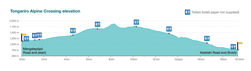
What is the Tongariro Alpine Crossing Elevation?
The Tongariro Alpine Crossing has a starting elevation of 1,120 meters above sea level, ascending to an altitude of 1,886 meters at the Red Crater. The track descends to finish at 760 meters.
How Fit Do I Need to Be to Hike the Tongariro Alpine Crossing?
The unique alpine environment of the Tongariro Alpine Crossing makes this intermediate trail a challenging yet rewarding one-day hike for most ability levels. There are uphill and sometimes steep areas of trail in both directions so a certain level of fitness is required. If you're not an experienced hiker, it's a good idea to do some practice hikes or walks on hills to prepare. Watch the New Zealand Mountain Safety Council walk-through video which outlines how to prepare for the track, facilities as well as hazards and typical conditions for the Tongariro area.
Are there multi-day hikes in Tongariro?
For adventurous hikers, you can tackle Tongariro Great Walk - the Northern Circuit to explore a larger variety of landscapes and vegetation compared to the Alpine Crossing route. You can complete it in 3-4 days with overnight stays in the huts. As an option, you can venture to the Mount Ruapehu area and try the Round the Mountain track in Tongariro which usually takes 4-5 days to complete. Both hikes offer amazing views of rugged mountains in the area.
The Tongariro Alpine Crossing Route has 6 sections
Mangatepopo Carpark to Soda Springs
Grade: Easy - allow 1-1.5 hours
You'll be dropped off at the Mangatepopo Tongariro Alpine Crossing Carpark by your shuttle. There are toilet facilities at the start of the track, then again around 20 minutes from the start (bring your own toilet paper!). The first section of the track is relatively flat and gives you a chance to warm up for the day ahead. Near the head of the Mangatepopo Valley, a 15-minute return sidetrack leads to the Soda Springs.
Soda Springs to South Crater
Grade: Moderate to Difficult - allow 45 minutes -1 hour
This section of the Tongariro Alpine Crossing track hosts the "Devil's Staircase", a tough climb climbing 200 metres in a short distance. The track surface here crosses lava flows and other volcanic debris, so pay attention to the changing walking surfaces.
South Crater to Red Crater
Grade: Moderate to Difficult - allow 1 hour
You'll find a welcome flat stretch here, followed by a rise on an exposed ridge to Red Crater. You've reached the highest Tongariro Alpine Crossing altitude, with stunning views wherever you look. This is the most exposed portion of the trail so stay aware of the weather and ground conditions.
Red Crater to Blue Lake
Grade: Moderate - allow 30 minutes
This section will leave you speechless as the Tongariro Alpine Crossing's famous turquoise lakes become visible. The descent from Red Crater needs to be hiked carefully, there's loose scoria [scree] on the steep descent, meaning you could lose your footing. The track then follows around the edge of the central crater and climbs back up to Blue Lake, which is a cold, acidic lake. The Blue Lake is sacred, so please do not touch it, swim in it, or eat around its shores.
Blue Lake to Ketetahi Hut
Grade: Moderate - 1 hour
To the right of Blue Lake, you will see Emerald Lake and will be able to smell the sulphurous odour coming from around the water. Emerald Lake is also sacred so please don't touch the water. After a short climb, you'll be on the edge of the North Crater, again with stunning views of the central plateau, before heading down to the Ketetahi Hut. There are toilet facilities at the Ketetahi Hut should you need them.
Ketetahi Hut to Ketetahi Carpark
Grade: Moderate - allow 2 hours
The Tongariro Alpine Crossing track crosses a stream here that flows down from Ketetahi Springs. Please note the springs are on private land and you must keep to the track. Follow the marked track down through the open tussock and down through the bush to the Ketetahi carpark. Depending on your transport choices, you'll meet you shuttle here.